It is now 3 months since I finished my walk. To be honest, I have had so much to do since returning home that I have often craved the simple routine of my long-distance trek. Having the responsibility of being a husband, parent, home-owner and provider – all of these duties shared, obviously – is a full-time task. Walking the best part of 1,100 miles, once the planning was done, is relatively uncomplicated by comparison.
As a project, there is no getting away from it, attempting a continuous walk from Lands End to John o’Groats pretty well tops the lot. Yes, you could walk further, climb higher, travel for longer, move faster, but these are all relative, and, perhaps, the realm of the obsessive. For an ordinary person, in this part of the world anyway, LEJOG is as testing an exercise as one might wish to undertake. It feels achievable and – unlike, for example rowing the Atlantic or sailing single-handedly around the world – it offers the safety net of never being far from civilisation and having the freedom to opt out at any time if the situation demands it. As a bonus, it has given me the chance to visit many parts of the country that I would never have got round to exploring.
Although the total distance walked, 1,079.5 miles, is significant, the individual days were often of a length similar to my normal Way Walks. Yes, some days were longer than I was comfortable with. I made the point often in my blog that I rarely thought about the total mileage or my end destination, only concentrating on the next day’s trek. Once I surpassed my previous longest continuous walk, the Pennine Way at 268 miles, it became increasingly apparent to me that the overall distance walked was of little relevance, other than as a footnote on the daily blog. Where it could have become a problem would be if I’d picked up an injury which couldn’t be ‘ walked off ’. I was incredibly lucky in this regard because the only medical issue I had was one blister on each foot, one after the other. I ignored the first one and it healed; the second one appeared soon after the first had gone but it persevered a bit longer. My 2 Carlisle rest days – giving me a couple of days at home – provided enough recovery time for it to go away never to return.
To help provide some order to this summary I will try and detail my thoughts under various headings that could be of help to anyone considering LEJOG. I am only noting thoughts that occur to me, answering questions that I have been asked and highlighting topics that may be of interest, or even an aid, to others.
DID I TRAIN FOR THE WALK BEFORE SETTING OFF?
The simple answer is ‘ no ’. I am fairly fit anyway and my normal lifestyle involves lots of exercise from walking around town rather than taking the car. It is rare for a week to go by without me doing at least one dedicated walk of a few miles.
There was so much to do in the last few weeks before setting out that my available time was at a premium, with many more important things to attend to rather than indulging in long walks. The first day, Lands End to Penzance, was only 13 miles, a gentle 4 hour walk at any time. The walking was fairly flat for the first 3 days and I did not anticipate encountering anything too taxing until Day 7 (Liskeard to Tavistock). Therefore I reckoned on the first 6 days as being a chance to build up my fitness. The strategy worked well and everything went according to plan. Days 7/8/9 presented my first early challenge because of the combination of distance and ascent. Once I overcame that potential hurdle then I was confident of reaching my first target, the city of Bristol.
HOW MUCH DID IT COST?
This ended up a very expensive adventure – but the cost was a lot less than I’d budgeted for. There is little point in detailing actual figures because inflation will ensure they are out-of-date before too long. Planning to walk through my home town allowed me to stay at home for a few nights either side, albeit with some extra travelling to and from each daily section. Including rest days, I spent 12 nights out of 79 in my own house. This left 67 nights where stopovers had to be paid for, often paying for single occupancy of a double room. Most places supplied an inclusive breakfast in the morning but there is a creeping change to charge this as an extra if establishments can get away with it. Premier Inn offer breakfast as an optional extra, Travelodge offer a breakfast box which didn’t contain anything that would have interested me; I had to be careful when using booking sites as the small print would often exclude any meals at all – even in what I thought were Bed & Breakfasts.
The accommodation in Cornwall, Devon and Somerset was quite reasonably priced but that could be because March was early season. Near the Lake District and for most of Scotland prices were above average. In some tourist hotspots it was difficult to source accommodation at any price… Fort William, Speanbridge (Gairlochy) and Drumnadrochit spring immediately to mind. At my stage in life I had no wish to stay in Youth Hostels, Backpackers’ Accommodation or Bunkhouses. As I weaved my way northwards I would sometimes opt for the extravagance of better quality rooms with en suite bathrooms, happy to pay a little more for the privacy and comfort.
If the accommodation cost was sometimes over budget, the food and drink element was mostly below budget. Where breakfast was included I would take it, whether hungry or not. I don’t recall ever being hungry during the day so rarely stopped for anything resembling lunch. I don’t even remember being hungry in the evenings but would always have an evening meal, often a one-course deal with drink in Wetherspoon. My evening meal in Crediton consisted of a portion of chips, as it did in another couple of stops.
For the first 4 weeks I had no appetite at any time. Whether this was caused by anxiety, nerves or some mental trigger is open to speculation – I have no way of knowing. It had no effect on my stamina so didn’t concern me. Thinking back, the first occasion that I remember being really hungry was my 2 day break at home after reaching Carlisle, Day 39, which was a full 6 weeks into the walk. Elizabeth’s home-made soup and fresh fruit salad was a great welcome home and I remember snacking constantly for the full 2 days.
WHETHER TO CAMP OR STAY IN HOTELS / B&Bs?
In all our years of walking we have never camped. Yes, I did consider sleeping under the stars when first starting to plan, solely with a view to keep the cost down. This idea was quickly discarded for 4 main reasons:
1. Reading other people’s blogs alerted me to the amount of extra weight involved in carrying camping gear. Not only would this slow you down, but, a recurring theme with those who had gone before me, was, that the punitive weight being carried caused serious blisters at the critical early stage of the venture. In some cases this caused people to abandon the walk, in others it caused discomfort all the way to the end.
2. It was prudent to assume that I would finish a fair number of days with wet gear. I had no wish to be carrying/wearing wet clothes, not on any walk, but especially not on LEJOG.
3. I had read other bloggers who had kept the weight down by travelling with almost no change of clothes. This resulted in a downgrading of attention to personal hygiene. I’m sorry, but this would have been a step too far for me (pardon the pun), as I needed to regularly hand-wash clothes, and try, however difficult, to cling to normal social standards.
4. The extra weight and bulk would have slowed me down and extended the length of time needed to complete the walk.
WAS IT EASIER WALKING WITH COMPANY OR ALONE?
There were benefits and drawbacks with both alternatives. I am quite relaxed with my own company, in fact that is one of the attractions of long-distance walking for me. Once I got into a daily routine it was certainly easier to walk on my own: I could start when I wanted, eat (or, more often, not eat) as the mood took me, go at whatever pace I felt like and alter my planned route on a whim.
But the real benefit of being alone kicked in once the day’s walk had finished. This was the point where I needed peace and space to plan ahead and also to make a record of how the walk had gone that day while it was fresh in my mind.
Companionship, on the other hand, made the walk pass quicker and offered another pair of eyes when following directions. The intermittent nature of when friends joined me broke the total walk up in to smaller segments and provided enough variety to keep the possibility of monotony at bay.
The next question expands on the importance of needing time to myself.
WHAT DID I DO WHEN NOT WALKING?
After I had located my accommodation and checked in there were a number of tasks that had to be addressed. I would first have to empty my pack and set about drying anything that was wet. At the same time I would plug in my multi-charger and get all my technology back to full power. If I had laundry to do then this had to be attended to as early as possible to give it the maximum time to dry – washing clothes by hand in a confined space is not fun. Then I would shower, make a cup of tea and phone/text home to let Elizabeth know I had finished the day safely. That left 2 important, time-consuming duties to now turn my attention to: first, planning the next day’s walk, and, second, writing my blog.
The single most important responsibility was attending to the following day’s walk: I would look out my pre-printed A4 sheets of the route, usually 4 pages, sometimes 3 if a shorter day, or 5 if a longer one; then I would go online using my Amazon Fire and log in to my account on the Ordnance Survey website, which in turn gave me access to the pre-plotted route for that day; I would then re-plot this information into my Satmap Active 20 GPS device, turn by turn. This meant that the upcoming route was fresh in my mind and I was fully aware of everything involved in the walk before setting off in the morning. I should add that this also involved me checking the exact location of my next day’s stopover and plotting directions which would hopefully take me to the front door. All of this could take me anything up to an hour and required total concentration.
Having attended to planning the next day meant I was now free to write up my blog. This was also done using the Amazon Fire. A note of explanation: I elected to buy the Amazon Fire because it was the lightest tablet I could find, while also being the cheapest. But I bought it for size/weight not for price, because this was going to be the heaviest item in my rucksack… and I was going to have to carry it for over 1,000 miles! Its limited ‘ App ’ store and plethora of adverts were particularly annoying. My daughter, Madeleine, got me around the former problem by finding a way to access Google Play Store before departing from home. I found it a cumbersome device when it came to writing the daily blog. Typing text was a laborious process – the predictive text at the top of the screen (6 suggestions) was seldom of any use. It also had the annoying habit of changing my typed word without me noticing. I could spend an hour and a half easily working on a blog which might end up as only 5 or 6 paragraphs. Having compiled something which I thought was acceptable I would then e-mail the finished article to my son, Peter, for him to polish up and put it on the blog. I then had to check the photos I had taken that day, select the best ones, label them, and then send these too to Peter. He had the responsibility of turning all these submissions in to a readable finished product – not an easy task when you are receiving this, often disjointed, information very late at night. He did a wonderful job of linking the pictures to the narrative, something I just couldn’t have found the time to do.
If you put the time required to perform all these essential tasks together then you will appreciate how pressurised the non-walking part of LEJOG was. The one thing I didn’t foresee was how little free time I would end up having. Being kept fully occupied turned out, with hindsight, to be a good thing because I was so busy attending to essentials that I didn’t have time to worry about what lay ahead. Bear in mind, on top of all this, I still had to source an evening meal and maybe an occasional relaxing drink. I also had to explore the internet to search, price, book and pay for accommodation in advance.
HOW FAR AHEAD DID I BOOK MY STOPOVERS?
I would book my stops an average of maybe 3 weeks ahead. Initially I booked right through to Bristol for reasons already explained. Sometimes the accommodation booking would allow me to cancel for free so this gave me a kind of insurance. Often, though, the deposit or full pre-payment would be forfeited if I couldn’t honour it, so it was a calculated risk on an ongoing basis. Once I was confident of continuing the walk after Bristol I tried to keep that 3 week window as I snaked my way up the country. If there was a shortage of available choices anywhere then I would try to secure that booking first and anchor the surrounding stops around it. I was flexible enough that I could alter my plan to take in any accommodation that wasn’t too far off route.
Pete booked the West Highland Way because that was a pressure point and I just didn’t have enough time to research it while travelling. I used all my rest days in sorting out accommodation ahead – so, to be truthful, they were anything but rest days!
The only obvious deviation to my scheduled path was when I had planned to go to Hyde (Day 28) but Pete booked us in to a motorway Premier Inn at Denton. This took me way off route, so my printed map pages were useless; it also forced me to cross 2 rivers where bridges were scarce… and it rained, so I arrived at the hotel soaked, and I had to negotiate my way through an industrial estate then a housing estate where the public rights of way disappeared completely (a recurring problem)! Pete, of course, opted for an early finish so arrived there earlier, nice and dry, by taxi. Sorry Hyde, but I didn’t get to appreciate your charms.
HOW DID MY FORWARD PLANNING WORK OUT?
As part of my essential preparation for LEJOG I had a spreadsheet of the whole walk in 69 daily sections, plus rest days. Detailed on this were:
– Day number
– Date
– Starting point
– Finishing point
– Projected walking mileage
– Cumulative mileage
– Daily ascent
– Canal, National Cycle Route or Way Walk involved plus the odd reminder note.
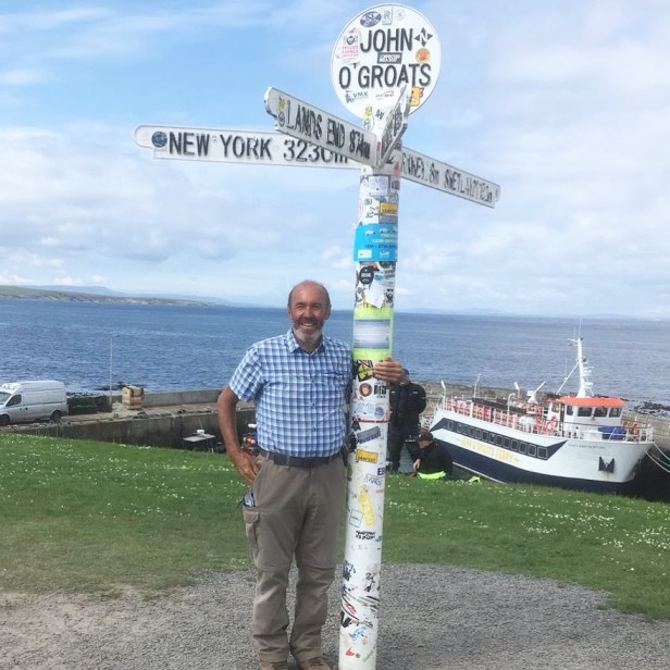
Through good luck I was able to stick to this schedule almost religiously through to the end, reaching John o’Groats on the very day I had planned to all those months before.
I also had handwritten A4 sheets with an average of 8 days to a page. These were constantly updated as I journeyed with details of possible stops for refreshment and the names, addresses and telephone numbers of each night’s accommodation. I also recorded the cost of each room and whether I had paid in advance or a deposit. Luckily this too worked out perfectly, so I encountered no blank faces or mistaken dates when appearing at somebody’s door hoping that I did indeed have a booking.
BEST DAY?
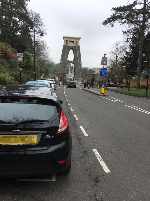
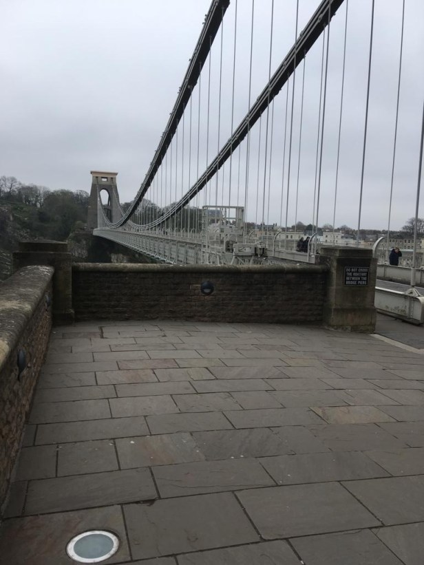
This is a difficult one. I enjoyed many days with all of my walking companions. No two days were the same. One highlight was walking across the Clifton Suspension Bridge on the way into Bristol. The sheer majesty of this 150 year-old structure which spans the Avon Gorge took my breath away. The crossing came at the end of an awkward day (Day 16) and it had me gazing over the spectacular countryside below with my mouth open.

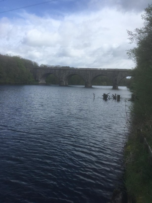
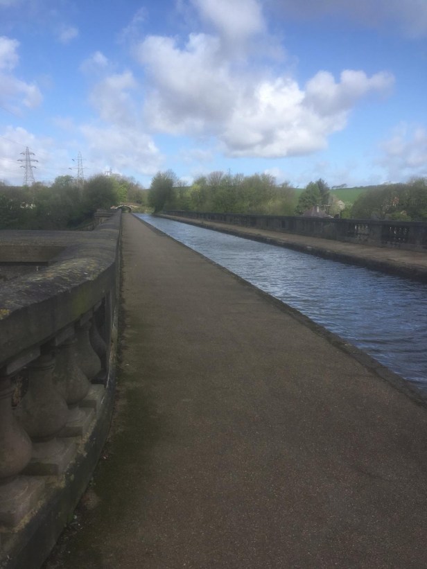
In a similar vein, the 220 year-old Lancaster Canal Aqueduct over the River Lune was unforgettable. I crossed this near the start of a pleasant day’s walking from Lancaster to Burton in Kendal (Day 35) and was amazed to have the whole structure to myself – no people, no boats, no dogs; just me and a wonderful view back to Lancaster.
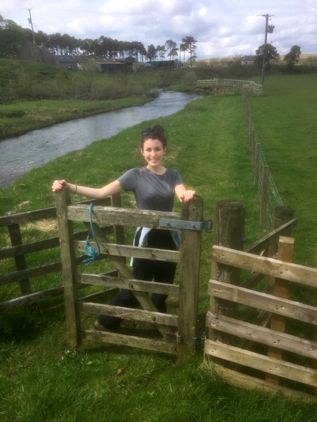
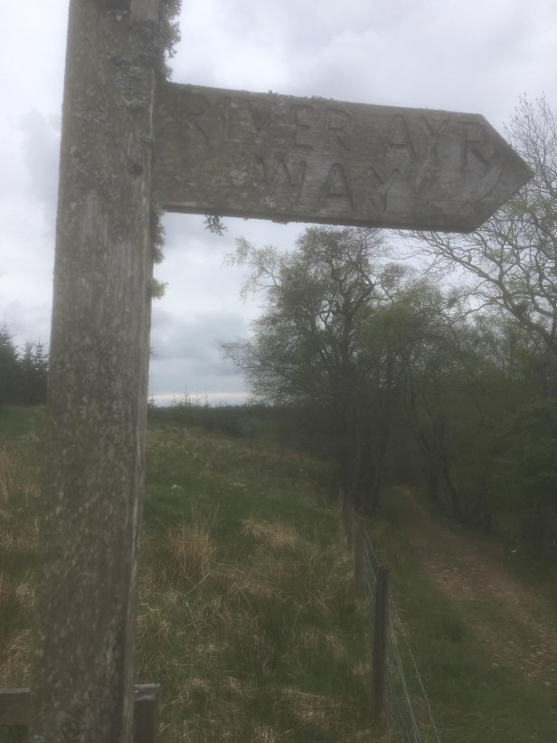
For an all-round satisfying day though I would probably plump for Day 46, Muirkirk to Sorn, following the River Ayr Way through East Ayrshire. Most of my days were spent following roads or canals but this section was a genuine Way Walk. Accompanied by my daughter, Madeleine, we walked through woods and fields and along the river bank, our only companions being a wide variety of birds, many of them waders, and lots of sheep. I had enjoyed this walk once before but savoured it even more this time, if only for the solitude. The path, bridges, stiles and way-posts were well-maintained and worthy of a heavier footfall.
Of course the West Highland Way and the Great Glen Way are outstanding, world-class walks, but I had to share these with lots of other people, so that diluted the splendour a little bit. Plus, I had done them a number of times previously so they held no surprises for me.

WORST DAY?
It sounds crazy but in 69 days walking I didn’t really have a bad day or a low point. Whether it was adrenalin or some other body chemical that kept me positive is difficult to tell. Even the long walking days left me feeling satisfied. The relatively few wet days had no negative impact either. My mood was maybe slightly dampened when saying goodbye to Christopher in Truro and setting off for St. Austell (Day 4) for my first section truly alone; this wasn’t helped by my slip later that day when I thought I had done a serious injury to my previously damaged ankle. All turned out well, luckily, and I had a relaxing stop in what turned out to be an exceptionally welcoming Guest House in St. Austell.

Likewise, when I said goodbye to my wife, Elizabeth, in Inverness, to head off towards Dingwall (Day 62), I felt a bit sorry for myself, but not for long. This was the final stretch and nothing was going to spoil the euphoria of the remaining few days.
If I had to pick the one day when everything conspired against me I suppose it would have to be Day 30, Manchester to Wigan. Through my own over-confidence I did what I had promised myself not to do, namely, change my route to shave a bit of distance off a long day. This took me off my printed maps and resulted in me having to take 3 separate detours. The ‘ shortcuts ’, instead of saving me mileage, actually added 5 miles to an already long day. Not only that, but it rained all day – my last rain, apart from 30 minutes before Inverness and some low-lying cloud leaving Dunbeath, of the whole walk. 39 days with no rain to speak of… I still shake my head in disbelief when I think of it!
But my problems that day weren’t yet over. I left the canal earlier than planned, mistakenly thinking I was near Wigan, only to realise that I was in fact only in Wigan District – and now completely off map! The rain was getting heavier as my state-of-the-art GPS decided to lock on me and my phone was a day short of my allowance getting reset, so I couldn’t access Google Maps. Essentially, for the first time in LEJOG I was walking blind, totally unaided. At least I was walking through a built-up area, and I knew I was going in the right general direction but I had no idea of how far I still had to walk to reach my destination. Trying not to alarm her, I stopped a lady walking hurriedly with two young schoolchildren and asked if this was Wigan town centre. I knew before she replied that I was not going to get the answer I hoped for. She suggested that I take a bus. ‘ I can’t take a bus ’, I said, in a slightly raised voice, without explaining my reasons. She then kindly stated that I was on the right road and would know that I’d reached Wigan when I came to a Lidl store. It was the best part of 2 miles before I finally got to my hotel. An 18-mile day had become a 23-mile day. I vowed never to change my pre-planned route again.
I should add that I subsequently discovered that the problem with my GPS was not the equipment itself but operator error – completely my own fault! I had fully used up the generous amount of memory provided on the device without realising it, because I had saved all my walks in their entirety. Most users don’t walk for 30 days non-stop, I suppose.
Having said all this, I still wasn’t upset or disheartened and have lots of nice memories of that day’s journey.

IF PLANNING THE WALK AGAIN, WHAT WOULD I DO DIFFERENTLY?
Again, at the risk of sounding annoyingly smug, I cannot think of anything I would change.
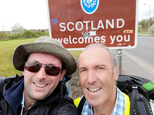
The time of year, April to June, with the days getting longer and the weather getting warmer, is ideal. The direction of travel was right, from south to north with the prevailing weather systems behind me rather than in my face. I also remember the feeling of elation as I crossed the border back in to Scotland, giving me a sense of being nearly home despite the fact that there were still 500 miles to go.
The route that I followed, using mainly roads and canals, is one that I would recommend to anybody attempting LEJOG. It is generally flat, straight and easy to follow. As I’ve stated previously, road-walking is not everybody’s cup of tea but it is unavoidable in a venture such as this. The object of the exercise is to get from Lands End to John o’Groats, so I see no point in making the task harder – and longer – by winding your way up hill and down dale unnecessarily just to piggy-back on established Way Walks. The Pennine Way and the Cotswold Way, for example, are terrific walks, and can serve a purpose if you’re not confident of planning your own route, but they’ll add time, cost and distance to your endeavours.
Crossing the border on the western side of the country, thereby allowing me to walk through my home town of Kilmarnock, was an inspired choice… for me, anyway! It allowed me to spend some time at home while also delivering savings in cost. More importantly, it broke the walk into 3 distinct sections: before home (6 weeks), at home (10 days) and after home (3 weeks). So, rather than being away for 3 months on the road, the longest part of the walk was reduced to 6 weeks. I appreciate that this wouldn’t work for everybody but it certainly worked for me.
My expensive GPS, Satmap Active 20, incorporating all the OS Maps for the UK, 1:50,000/1:25,000/1:10,000 was worth its weight in gold – in fact, gold might have been cheaper! Talking about weight, it wasn’t the lightest. It was my constant companion for all 1,079.5 miles, even when I knew my route. I have no doubt that this little gem of technology gave me the confidence to tackle this venture on my own. The walker I met and chatted to on Day 60, Invermoriston to Drumnadrochit, had walked as long as me using only a compass – he was doing a more remote walk than I was and said he had only needed to refer to his navigational aid 6 times! Well, did I feel humbled, but each to his own!
Everything in my pack was thought through a number of times before setting out. Thankfully the modern walking gear is lightweight, generally windproof – and at least water-resistant if not always completely waterproof. When my walking trousers got wet they dried very quickly. All my clothes were easily hand-washed and everything, possibly bar my walking socks, dried perfectly overnight. I only remember wearing my waterproof over-trousers maybe 3 times in total.
I love Ordnance Survey maps but they would have been too heavy to carry, probably needing about a dozen at a time. Paying an annual subscription to OS (about £20 as I write) allowed me to plot my route online and save it. Then I downloaded and printed off each individual day-walk on A4 1:25,000 (Explorer) sheets. This did add a considerable amount of weight at the start because I had to carry the full route from Lands End to Carlisle. I discarded these as I travelled along and loaded up with each subsequent section while staying at home. Along with my GPS this gave me 2 separate navigational aids; one backing up the other if required. The strategy worked perfectly and only became a bit suspect when I veered off my pre-plotted route, but, apart from the glitch at Wigan, as explained above, my GPS – because it was pre-loaded with all the maps – could cope with any deviation. I had a third option for navigating, Google Maps on my phone, but I was wary of taking my phone out when it was raining.
The weight of my pack (8 kilos when setting off) was acceptable. We would normally walk as a group carrying only light daypacks and take advantage of baggage transfer or taxi for our heavier gear. Walking on my own made this impractical from the point of view of cost and logistics. I took the precaution of doing a solo walk last year, the Ayrshire Coastal Path, when I carried a full pack with no obvious discomfort. So it proved on LEJOG, although I did treat myself, after some research, to a new ‘Osprey Exos 48’ backpack. When loaded, the pack seemed heavy to lift at first, but once it was on my back I hardly noticed the extra weight. As with other gear, I think it was important to buy the best equipment I could afford because that could be the difference between success and failure.
Meticulous planning was key to the whole venture. When I physically walked the route each day this was, in effect, the third time I had done it; the first time was when I had plotted it and saved it on my OS site in the comfort of my own home; the second time was when I had re-plotted it on to my GPS the night before walking; and the third time was the walk itself. My rucksack, GPS, boots, walking trousers, in fact all my gear was quite deliberately selected and purchased with LEJOG in mind – and everything performed as I had hoped.
To conclude, I feel I should mention how the plotted route, using Ordnance Survey maps, worked out in practice.
Public Rights of Way (paths, essentially) are marked on OS maps in the UK but not in Scotland. Where I thought they would be helpful, and to get me away from road traffic, I plotted them into the walk. I quickly discovered that often these paths were a hindrance rather than a help. On the very first day, walking from Lands End to Penzance, in Cornwall, I found most paths were either, unmarked, overgrown, ploughed up, flooded or downright impassible. This set the pattern for the rest of the walk where my default choice was now to follow a minor road to avoid a path rather than take a path to avoid the road. Canal towpaths were generally in good condition and it was easy to make good progress on them.
Sadly, Ordnance Survey do not mark Public Rights of Way on their maps in Scotland. I assume this is because of the ‘ Right to Roam ’ in Scotland. I don’t fully understand this recent law but do know that I have no wish to go trekking over land which the owners might consider private, at the same time encountering locked gates, ditches, bulls, aggressive dogs and countless other deliberate obstacles. Because of this, I probably ended up doing more road-walking in Scotland than I had to.
A postscript to this last point is the John o’Groats Trail which goes from the end of the Great Glen Way, in Inverness, to, I think eventually, John o’Groats. It is in the process of development with some parts signposted. I studied what was available when originally planning my walk but decided it was not going to be much use to me. A lot of the route is rough, rugged (if not downright dangerous) and physically demanding. It would also have added distance and time to the walk for little apparent benefit. As much as I didn’t relish the prospect of prolonged road-walking in Sutherland and Caithness it still seemed the sensible option. Maybe things will change as they develop the JOG Trail.
THE END BIT
I feel I have covered most things I wanted to say with this summary. If you have something specific you want to ask, or even just wish to drop me a line then please do so using the ‘ Get in touch with me ’ link at the top of the page. I would love to get feedback, especially if any of this has been helpful in planning your own walk. My detailed inventory of everything I took on my adventure is still to be posted, as has a more specific explanation of how I planned the route.
Peter will, time permitting, continue to upgrade the blog and make it more user-friendly. The links already posted, which cover my planned route, are the original ones plotted prior to starting. We will gradually update these to take into account where I had to alter my route because the paths didn’t exist or proved impractical when I actually got there.
Physically I have suffered no ill-effects from walking the best part of 1,100 miles; the stone and a half (10 kilos) in weight that I lost has gradually been replaced – I am now only 4 kilos lighter than when I started in Cornwall.
Walking from Lands End to John o’Groats has been one of the most exhilarating things I have ever done in my whole life. It was a wonderful adventure, taking me to parts of the country I would never have visited and meeting so many interesting people I would never have encountered. The fellow walkers that I met and talked to made the whole experience a joy. Long-distance walkers seem to be mostly individuals, self-motivated but not anti-social. On the contrary, I feel as if each one I spoke to was exceptionally friendly and, whether we chatted for 3 minutes or 30, we all had something in common, kindred spirits living life, for a short while, at a gentle pace. It was a personal journey of enlightenment and it’s free for anybody to try… at any age.
Thanks for sharing my adventure with me.